Prospects of a collaborative database for tree biodiversity conservation
1. Tree diversity in modified environments
Forests natural species diversity varies with the climate and is at highest in tropical regions. For example, 1173 tree species have been recorded in 50 ha of Malaysian jungle forest which is more than the estimated native trees in the whole temperate northern hemisphere. If tree populations have evolved in equilibrium with climate changes, their distributions and interactions with the environment have undergone drastic modifications with the development of agriculture and urbanization. However, the choice of the origin and kind of planting material has consequences on the ecosystems diversity and evolution that easily escape the perception of local decision makers if not monitored over an appropriate space and timescale. As illustration, populations of European poplar (Populus nigra) have become vulnerable not only due to the alteration of their natural habitat but also due to genetic pollution trough the pollination by extensive plantation of single varieties and clones. P. nigra benefits currently from long term in-situ and ex-situ conservation measures involving a network of 21 countries. Similarly, planning plantations of appropriate local tree and shrub species in urbanized environments with a high intra-specific diversity would significantly reinforce ex-situ conservation capacities for trees and increase beneficial interactions with surrounding and less disturbed ecosystems. At present only a few species with low intra-specific diversity are used in urban forestry. Among the difficulties for increasing this diversity is the lack of knowledge of local trees properties as well as their availability in nurseries. This limitation combined to low awareness about the functions of local plants diversity restricts plantation campaigns to a single dimension of “going green” whereas there is a widely untapped potential to improve the integration of street trees, private gardens, parks and woodlands in a conservation network for biodiversity and cultural identity.
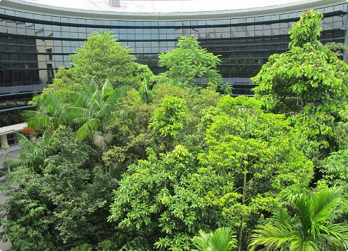
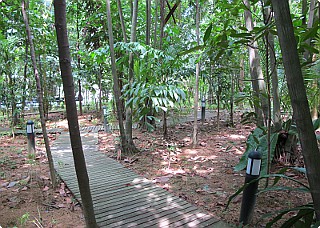 Tropical tree grove in a modified environment
Various species unsuitable for alignment plantation can be maintained in groves. Monitoring plant-plant associations in different situations and combinations would complement the understanding of natural tree dynamics of mega diverse forests with experimental knowledge. This plantation at the library of the National Institute of Education in Singapore has been inspired from the “man made jungle” of the Kuala Lumpur international airport in Malaysia. It includes some of the local threatened Dipterocarpaceae species. Visitors have a restful view on the canopy and can immerse themselves for a moment into a jungle atmosphere at the ground floor where the canteen is opened to a boardwalk.
2. Collaborative and socially embedded biodiversity management
The organization of complex environment increasingly relies on the assistance of Geographic Information Systems (GIS) for displaying and analyzing spatial processes. Many cities have started recording park and alignment trees in GIS. Interoperating these systems with the Geoweb for consultation and collection of data by the public, researcher and relevant stakeholders will improve action capacities for integrated biodiversity conservation. Some results to be expected from that approach can be evoked:
- Multiples actors contribute to data collection reducing operation costs. For example city contractors complete and exchange tree information on a website during routine tree-care servicing or initial planting.
- Management decisions and proposals for biodiversity conservation are presented to citizens and decisions makers on evidence basis. Class activities can be integrated to real-problem solving, increasing the motivation of students for learning.
- Investigations on the benefits of plant-plant and plant-fungi associations are planned and monitored in a large variety of situations. Low maintenance growth protocols are defined for the growth of environmentally sensitive species in city parks, hotel gardens, etc.
- Comprehensive biodiversity management plans including desired tree provenances are linked with in-situ conservation programs. Nurseries, seed collectors and research institutes anticipate future collaborations, services and markets. Private gardeners are aware on how their choices impact ecological functions.
- Conservation strategies integrate single the management of single trees at a local, regional and international level.
3. Moving towards databases interoperability: the case of pericopsis.org
Public feedback and customized contact forms
To benefit fully from pericopsis.org Wiki functions, e-mail of a person in charge of the plantations needs to be communicated for receiving public feedback and automated e-mail when tree names have been edited. On demand to the webmaster, forms can be customized for specific needs and services such as the report of a problem with a tree, the request of a service, a survey etc. Data from the form can be addressed either as an e-mail to a delegated person or directly send to a private database.
Standard for tree names
Data exchanges require a reference for scientific names. New entries are checked against the International Plant Name Index (IPNI). Scientific names that are not in the IPNI can be sent by e-mail to the webmaster. The experience showed that the most common modifications applied to published tree lists were related to typography and confusions between the scientific and horticultural cultivated variety (cultivar) names. Horticultural names, usually written between simple quotes, are not following the standards of scientific names. Nevertheless, the presence of a cultivated variety is precious biodiversity information and should be mentioned whenever possible. Since there is currently no equivalent of the IPNI for horticultural names, pericopsis stores a web link to a webpage mentioning the cultivar. Family, genera and species names are stored in pericopsis.org under double indexes allowing synonyms of scientific names to be used indifferently. Equivalences between synonyms and accepted names will be established by the webmaster once relations are identified. Contributors are welcome to contact the webmaster for any suggestions of synonym equivalences. “x” is used as species for hybrid cultivars. Pericopsis allows the combination of two names to form a hybrid (the order of the name has no importance in that case). This option can be advantageous for mapping natural or semi natural populations but should not be used if a cultivated variety or a scientific name already characterizes the hybrid. For better interoperability, cities should plan data lists that differentiate family, genus, species and, if opportune, an infra-specific name with appropriate epithet (subsp., var., f.). The cultivated variety should also be distinguished from the scientific name.
Standard for tree positions
Pericopsis.org position coordinates are entered and exported in the decimal EPSG: 4326 - WGS84 format with a maximal precision of six digits after the decimal point (0.11 m at latitude 0). Data conversions to other projections can be operated from downloaded SHAPE files using classic GIS packages as for example ArcMap (ESRI) or Quantum GIS (open source). The rule is a single tree for each position. Pericopsis rejects any second tree having the same or a side by side adjacent coordinate. The minimal distance between two trees is therefore 0.22 m at latitude 0. This rule affected for example the compatibility of 0.8% of Paris and 32% of New York Brooklyn trees. Such problem could arise if replaced trees are not removed form the data list or if the position accuracy is too low.
4. Call for collaboration and future developments
Updating city databases on pericopsis.org
Each city has its own data system and management plans. Interoperability for automated database update can therefore be developed in an adaptive and progressive way. Interested cities, persons in charge of tree plantations, botanical gardens are welcome contacting the webmaster to define a suitable method for automating data update either from an existing database or a newly created one. Implemented approaches will be published on pericopsis.org.
Interoperability with other websites
On a longer term, a decentralization of the collaborative tree database and web services for data updates is envisaged. In that case links between independent websites and databases should be built on common identification numbers for each tree, tree name and contributor distributed by a single reference server. Partners willing to join for developing a prototype for such network based on SQL or XML exchanges protocols are welcome to contact the webmaster.
Management of populations
Intra-specific diversity is a main factor for species conservation as it determines their capacity of adaptation to environmental changes such as climate change, pest outbreak, etc. The maintenance of this diversity in modified and managed ecosystems requires tracing the provenance of seeds and/or to identify a number of different clones able to represent a part of the natural population diversity. In absence of molecular studies able to characterize a set of representative clones, a higher level of provenances diversity could be targeted when seeds are collected over the largest possible and relatively undisturbed natural distribution area. In this context spatial databases allow associating to each tree the location of the parental tree in form of a point. Cities, nurseries or organisms accredited for collecting seeds in undisturbed environments are warmly invited to contact the webmaster for advertising their approach. A system for indicating the tree provenances in form of a clone name or provenance coordinate is planned on pericopsis.org.