Consulting the database
How to show the trees?
Queries are made under the link "Consultation". Trees recorded in the database are shown on the map simply
by clicking the button . Trees will be represented by green tags  having a dot if there are hybrids
If no tree tag appears on the map, it might be needed zooming-out by clicking on the map upper-leftminus sign.
Clicking on a green tag will show the corresponding tree features. Different symbols, for some clickable, are used:
 Displays the name of the first person that recorded the tree.
 Indicates that the author is not sure about its identification.
 Displays previously recorded tree names.
 Indicates that the deleted tree will be removed from the database soon
 Displays recorded diameter values.
 Displays a link associated to the tree.
 Displays messages associated to the tree.
 Displays a link associated to the cultivar name.
 Displays a link associated to a second cultivar name in case of hybrids
(x) indicates that the tree is a hybrid without specific hybrid name.
(+) indicates a grafting. Names of the hybrids parents or grafted species can be alternated by clicking on the tree tag.
It is also possible to select displayed trees by their scientific name using the “Categories” list box.
Trees corresponding to the selected names will appear in pink  . Trees tagged as half green and half
pink correspond either to hybrids that have no hybrid name  or to grafted trees
  .
.
How to filter the query?
The display of  indicates that the maximum of 200 displayed trees has been reached.
To diminish the number of results it is possible to use the selection filters by clicking on the
selection criteria and choosing the proposed options.
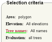
1. Filter by Area
- Area delimited by a polygon
- Loading a polygon
- Select trees in a country
An area of interest can be directly drawn by clicking on the map. Yellow markers will appear that form
a polygon. Only the trees in the polygon will be selected.
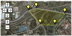
Area delimited by a polygon
If a registered user recorded a polygon, it can be loaded by entering the user name.
Usernames are case sensitive ex: tintin and Tintin are considered as two different names.

Example of loading a polygon recorded by "Tintin"
Only trees that occur in the country selected in the list box in “Tree position” will be returned.
Country names given by Google map reverse geocoding services were arbitrary taken as a reference.
2. Filter by Elevation range
Ticking the select elevation range option permits to chose trees that occur in chosen elevation range.
3. Filter by Tree names
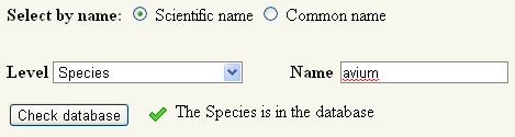
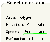
Tree name can be selected either by scientific or common names. Before clicking the "Show tree" button the presence of the desired tree name in the database needs to be checked . For example for "Prunus avium","Prunus" is the genus and "avium" is the species name. To check if the species is in the database it is needed to select "Species" in the level scroll and to enter "avium". Another possibility is to select "Within genus (species)" in the level scroll and to enter Prunus. The database will then return all species within the genus Prunus. The database of pericopsis was empty at the beginning, it is completed step by step by the contributions of the users.
a. click on tree name
b. Select species and enter avium
Another option is to select Species, enter Prunus and select avium
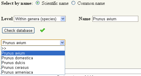
c. Check the selection
4. Filter by Evaluation
Tree names can be selected according the evaluation of their naming as "sure" or "unsure".